NYRR Washington Heights Salsa, Blues and Shamrocks 5K
Park at Fort Lee and run across Washington Bridge
– Metered parking is free on Sunday.
– All Fort Lee Municipal Parking lots are enforced 24 hours a day, 7 days a week (except Holidays). Note: Not free on Sunday
– Municipal Parking lots rate is $2.00 per hour for the first 3 hours and $3.00 for every additional hour after the three hours up to maximum time per parking lot.
For more information visit: https://www.fortleenj.org/394/Metered-Parking
Parking Locations:
1) Landmark: Kuba Restaurant
Address: 2139 Hudson Terrace, Fort Lee, NJ 07024
GPS 40.8546560, -73.9632498
Map: https://maps.app.goo.gl/A7sq6MebYEKwnv3Z6
Number of spots (estimate): 20
2) Landmark: Main Street Business Lot
Address: 2020 Central Rd, Fort Lee, NJ 07024
GPS 40.8511763, -73.9658139
Map: https://maps.app.goo.gl/yiCcQ27HjWph23cV8
Number of spots: 9
3) Landmark: Enterprise Rent-A-Car
Address: 321 Bruce Reynolds Blvd
GPS 40.8534233, -73.9680351
Map: https://maps.app.goo.gl/6S92oHJncqYDaPsVA
Number of spots (estimate): 12
4) Landmark: A1 Towing and Auto Repair
Address: 209 Cross St
GPS 40.8550697, -73.9673036
Map: https://maps.app.goo.gl/3vPqgK2ezT78QMsV9
Number of spots: 9
5) Landmark: NewBank
Address: 475 Park Ave
GPS 40.8522598, -73.967645
Map: https://maps.app.goo.gl/v2AS374RGQvMdvPX7
Number of spots: 7
6) Landmark: Linwood Wine – Hudson Lights
Address: On Central Ave by 675 Park Ave
GPS 40.8525022, -73.9680320
Map: https://maps.app.goo.gl/aQcuWgC8N5EYvamN9
Number of spots: 11
7) Landmark: PinPod
Address: 2025 Hudson St
GPS 40.8520833, -73.9687827
Map: https://maps.app.goo.gl/Hn1xheiyWnojyVTMA
Number of spots: 25
8) Landmark: Paris Koh Find Arts
Address: 201 Brg Plz N #1, Fort Lee, NJ 07024
GPS 40.8556185, -73.9689530
Map: https://maps.app.goo.gl/NoTXPYEGMYf3TcFR7
Number of spots: 20
All 8 stops:
Start from Lotte Plaza by 95 / NJTP::
Start from Lotte Plaza by GSP:
Northwalk (New Jersey)
Address: 2145 County Rd 505, Fort Lee, NJ 07024
GPS 40.854061465691224, -73.96330653556444
Map: https://maps.app.goo.gl/n315GtgLr1PMwcNX6
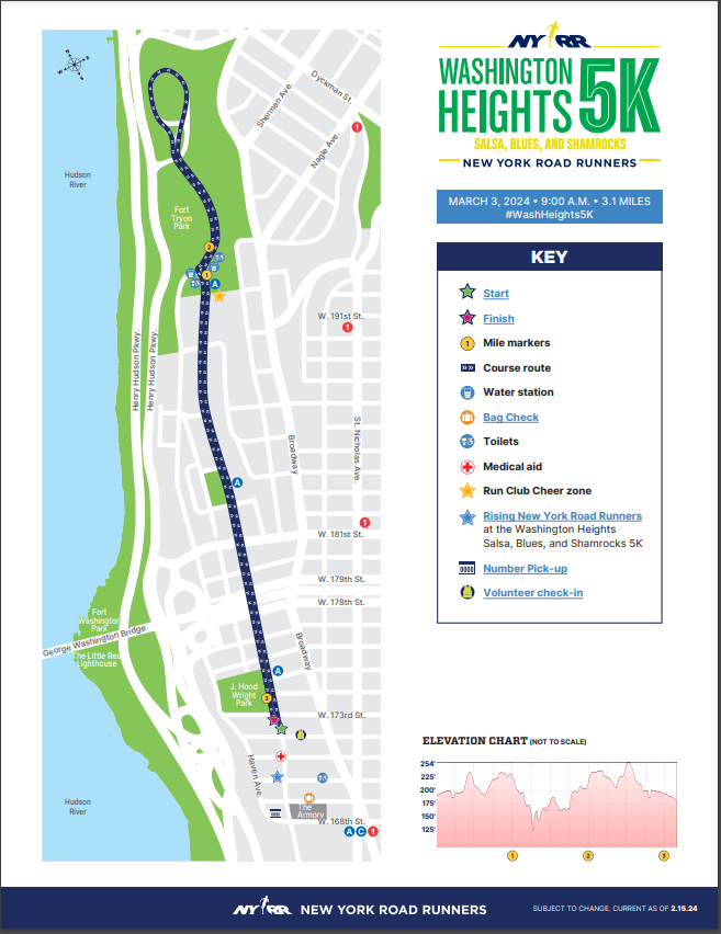
Race Start:
GPS 40.84484976380241, -73.94074734491043
Map: https://maps.app.goo.gl/prsNw9HABHy5Qxv46
Start on Fort Washington Avenue between West 172nd and 173rd streets, and begin running north on Fort Washington Avenue. You will reach the one-mile mark at the end of Fort Washington Avenue, as you approach the entrance to Fort Tryon Park. This is also the location of the Run Club Cheer Zone, where members of local club teams can support their runners on the way in and out of the park.
Run a counter-clockwise loop of the roadway in Fort Tryon Park, running downhill in the first half of mile 2 and uphill on the second half; you will reach the two-mile mark shortly before exiting the park. Continue out of the park and back onto Fort Washington Avenue, and follow that road south to the finish line on Fort Washington Avenue just beyond West 173rd Street.